Showing:

Annotations
Attributes
Diagrams
Instances
Model
Properties
Source
Used by
Element diggs:LithologyObservation
Namespace http://diggsml.org/schemas/3
Annotations
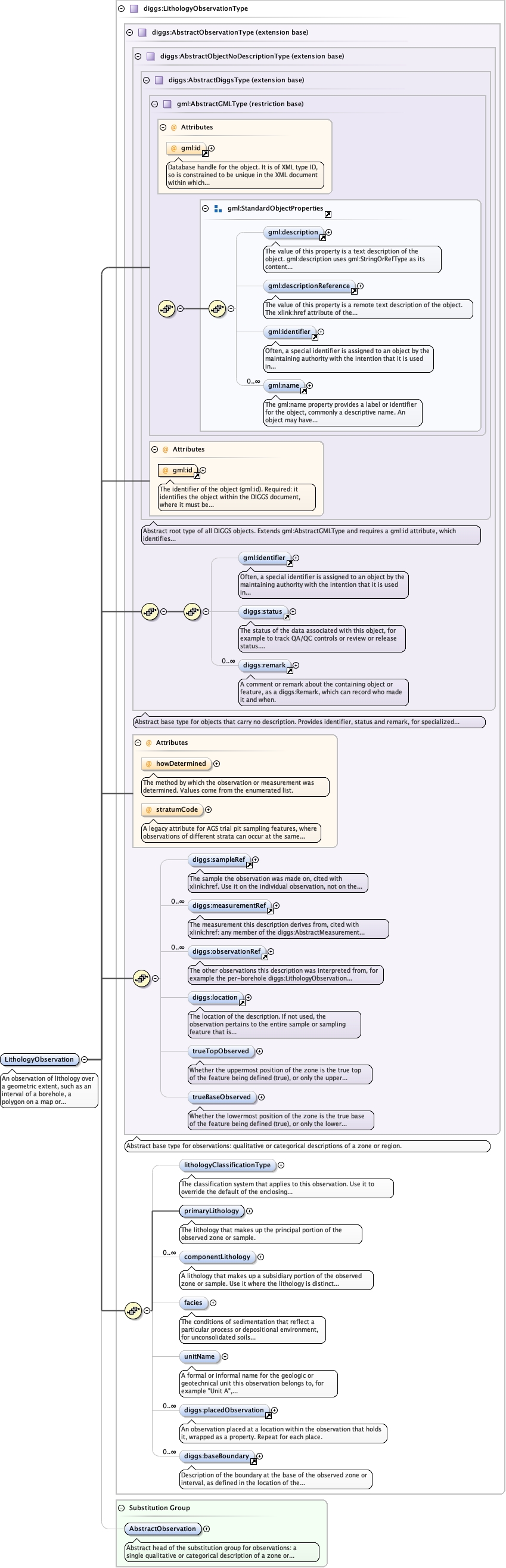
An observation of lithology over a geometric extent, such as an interval of a
borehole, a polygon on a map or cross-section, or a volume. It holds the primary and
component lithologies, ancillary observations within the extent (placedObservation)
and the conditions marking the basal boundary of the lithology.
Diagram
Diagramgml3_2Profile_diggs_xsd_Attribute_gml_id.tmp#idgml3_2Profile_diggs_xsd_Element_gml_description.tmp#descriptiongml3_2Profile_diggs_xsd_Element_gml_descriptionReference.tmp#descriptionReferencegml3_2Profile_diggs_xsd_Element_gml_identifier.tmp#identifiergml3_2Profile_diggs_xsd_Element_gml_name.tmp#namegml3_2Profile_diggs_xsd_Element_Group_gml_StandardObjectProperties.tmp#StandardObjectPropertiesgml3_2Profile_diggs_xsd_Complex_Type_gml_AbstractGMLType.tmp#AbstractGMLTypegml3_2Profile_diggs_xsd_Attribute_gml_id.tmp#idAbstractTypes_xsd_Complex_Type_diggs_AbstractDiggsType.tmp#AbstractDiggsTypegml3_2Profile_diggs_xsd_Element_gml_identifier.tmp#identifierCommon_xsd_Element_diggs_status.tmp#statusCommon_xsd_Element_diggs_remark_1.tmp#http___diggsml.org_schemas_3_remarkAbstractTypes_xsd_Complex_Type_diggs_AbstractObjectNoDescriptionType.tmp#AbstractObjectNoDescriptionTypeAbstractTypes_xsd_Complex_Type_diggs_AbstractObservationType.tmp#AbstractObservationType_howDeterminedAbstractTypes_xsd_Complex_Type_diggs_AbstractObservationType.tmp#AbstractObservationType_stratumCodeCommon_xsd_Element_diggs_sampleRef.tmp#sampleRefCommon_xsd_Element_diggs_measurementRef.tmp#measurementRefCommon_xsd_Element_diggs_observationRef.tmp#observationRefCommon_xsd_Element_diggs_location.tmp#locationAbstractTypes_xsd_Complex_Type_diggs_AbstractObservationType.tmp#AbstractObservationType_trueTopObservedAbstractTypes_xsd_Complex_Type_diggs_AbstractObservationType.tmp#AbstractObservationType_trueBaseObservedAbstractTypes_xsd_Complex_Type_diggs_AbstractObservationType.tmp#AbstractObservationTypeCore_xsd_Complex_Type_diggs_LithologyObservationType.tmp#LithologyObservationType_lithologyClassificationTypeCore_xsd_Complex_Type_diggs_LithologyObservationType.tmp#LithologyObservationType_primaryLithologyCore_xsd_Complex_Type_diggs_LithologyObservationType.tmp#LithologyObservationType_componentLithologyCore_xsd_Complex_Type_diggs_LithologyObservationType.tmp#LithologyObservationType_faciesCore_xsd_Complex_Type_diggs_LithologyObservationType.tmp#LithologyObservationType_unitNameCore_xsd_Element_diggs_placedObservation_1.tmp#placedObservationCommon_xsd_Element_diggs_baseBoundary.tmp#baseBoundaryCore_xsd_Complex_Type_diggs_LithologyObservationType.tmp#LithologyObservationTypeAbstractTypes_xsd_Element_diggs_AbstractObservation.tmp#AbstractObservation
Type diggs:LithologyObservationType
Type hierarchy
Properties
content complex
Substitution Group Affiliation
Used by
Model
Children diggs:baseBoundary, diggs:componentLithology, diggs:facies, diggs:lithologyClassificationType, diggs:location, diggs:measurementRef, diggs:observationRef, diggs:placedObservation, diggs:primaryLithology, diggs:remark, diggs:sampleRef, diggs:status, diggs:trueBaseObserved, diggs:trueTopObserved, diggs:unitName, gml:identifier
Instance
<diggs:LithologyObservation howDetermined="" gml:id="" stratumCode="" xmlns:diggs="http://diggsml.org/schemas/3" xmlns:gml="http://www.opengis.net/gml/3.2">
  <gml:identifier codeSpace="">{0,1}</gml:identifier>
  <diggs:status codeSpace="">{0,1}</diggs:status>
  <diggs:remark>{0,unbounded}</diggs:remark>
  <diggs:sampleRef xlink:href="" identifierRef="" nilReason="" owns="false" percentage="">{0,1}</diggs:sampleRef>
  <diggs:measurementRef xlink:href="" identifierRef="" nilReason="" owns="false">{0,unbounded}</diggs:measurementRef>
  <diggs:observationRef xlink:href="" identifierRef="" nilReason="" owns="false">{0,unbounded}</diggs:observationRef>
  <diggs:location owns="false" xlink:href="" nilReason="">{0,1}</diggs:location>
  <diggs:trueTopObserved>{0,1}</diggs:trueTopObserved>
  <diggs:trueBaseObserved>{0,1}</diggs:trueBaseObserved>
  <diggs:lithologyClassificationType codeSpace="">{0,1}</diggs:lithologyClassificationType>
  <diggs:primaryLithology xlink:href="" nilReason="">{1,1}</diggs:primaryLithology>
  <diggs:componentLithology>{0,unbounded}</diggs:componentLithology>
  <diggs:facies>{0,1}</diggs:facies>
  <diggs:unitName>{0,1}</diggs:unitName>
  <diggs:placedObservation>{0,unbounded}</diggs:placedObservation>
  <diggs:baseBoundary>{0,unbounded}</diggs:baseBoundary>
</diggs:LithologyObservation>
Attributes
QName Type Use Annotation
gml:id ID required
Database handle for the object. It is of XML type ID, so is constrained to be
unique in the XML document within which it occurs. An external identifier for the object in
the form of a URI may be constructed using standard XML and XPointer methods. This is done
by concatenating the URI for the document, a fragment separator, and the value of the id
attribute.
howDetermined diggs:DescriptorMethodEnumType optional
The method by which the observation or measurement was determined.
Values come from the enumerated list.
stratumCode string optional
A legacy attribute for AGS trial pit sampling features, where
observations of different strata can occur at the same depth in a pit: a
reference letter or number whose sole purpose is to link the stratum on
the face sketch of the trial pit to the observation.
Source
<element name="LithologyObservation" type="diggs:LithologyObservationType" substitutionGroup="diggs:AbstractObservation">
  <annotation>
    <documentation>An observation of lithology over a geometric extent, such as an interval of a borehole, a polygon on a map or cross-section, or a volume. It holds the primary and component lithologies, ancillary observations within the extent (placedObservation) and the conditions marking the basal boundary of the lithology.</documentation>
  </annotation>
</element>