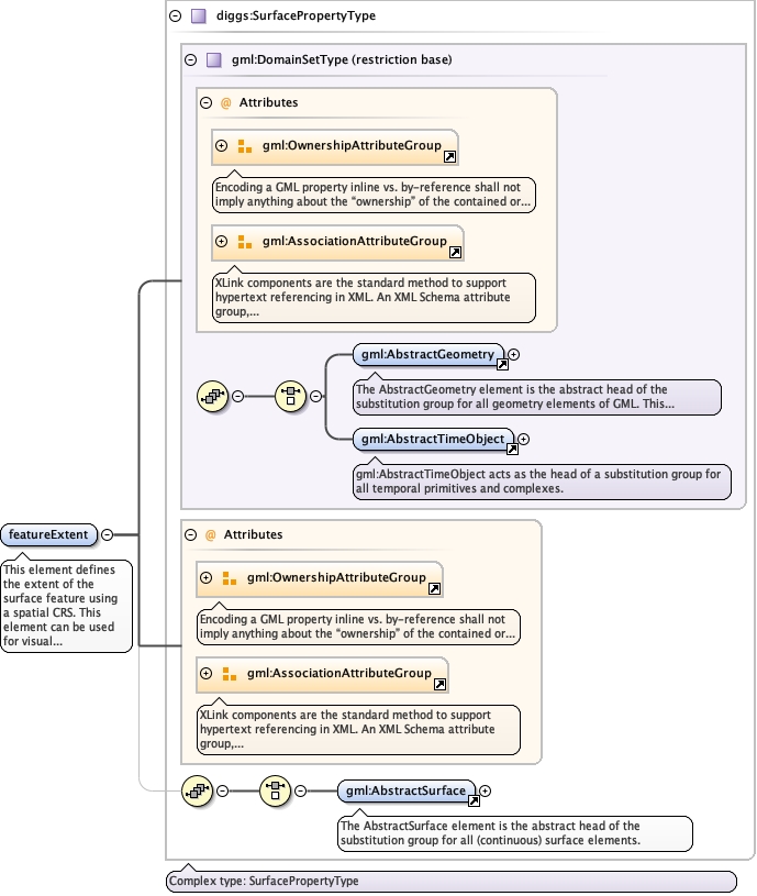
This element defines the extent of the surfacefeature using a spatial CRS. This element can be used forvisual representations using typical/simple mappingsoftware. Either this element, or relativeFeatureExtent isrequired, and can be optionally added ifrelativeFeatureExtent is used.
The 'actuate' attribute is used to communicate the desired timing of traversal from the starting resource to the ending resource; it's value should be treated as follows:onLoad - traverse to the ending resource immediately on loading the starting resource onRequest - traverse from the starting resource to the ending resource only on a post-loading event triggered for this purpose other - behavior is unconstrained; examine other markup in link for hints none - behavior is unconstrained
The 'show' attribute is used to communicate the desired presentation of the ending resource on traversal from the starting resource; it's value should be treated as follows: new - load ending resource in a new window, frame, pane, or other presentation contextreplace - load the resource in the same window, frame, pane, or other presentation contextembed - load ending resource in place of the presentation of the starting resourceother - behavior is unconstrained; examine other markup in the link for hints none - behavior is unconstrained
<element name="featureExtent" type="diggs:SurfacePropertyType" maxOccurs="1" minOccurs="1"><annotation><documentation>This element defines the extent of the surface feature using a spatial CRS. This element can be used for visual representations using typical/simple mapping software. Either this element, or relativeFeatureExtent is required, and can be optionally added if relativeFeatureExtent is used.</documentation></annotation></element>
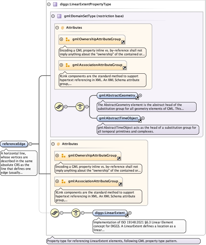
A horizontal line, whose vertices are describedin the same absolute CRS as the line that defines one edge(usually either the top or bottom edge)of the samplingfeature’s surface. Where appropriate, this unit is used torepresent the intersection of a 2D surface with the ground,or more commonly, when a single line (2 vertices only), isused to represent the x-axis of a 2D or 3D localCRS.
The 'actuate' attribute is used to communicate the desired timing of traversal from the starting resource to the ending resource; it's value should be treated as follows:onLoad - traverse to the ending resource immediately on loading the starting resource onRequest - traverse from the starting resource to the ending resource only on a post-loading event triggered for this purpose other - behavior is unconstrained; examine other markup in link for hints none - behavior is unconstrained
The 'show' attribute is used to communicate the desired presentation of the ending resource on traversal from the starting resource; it's value should be treated as follows: new - load ending resource in a new window, frame, pane, or other presentation contextreplace - load the resource in the same window, frame, pane, or other presentation contextembed - load ending resource in place of the presentation of the starting resourceother - behavior is unconstrained; examine other markup in the link for hints none - behavior is unconstrained
<element name="referenceEdge" type="diggs:LinearExtentPropertyType" minOccurs="1" maxOccurs="1"><annotation><documentation>A horizontal line, whose vertices are described in the same absolute CRS as the line that defines one edge (usually either the top or bottom edge)of the sampling feature’s surface. Where appropriate, this unit is used to represent the intersection of a 2D surface with the ground, or more commonly, when a single line (2 vertices only), is used to represent the x-axis of a 2D or 3D local CRS.</documentation></annotation></element>
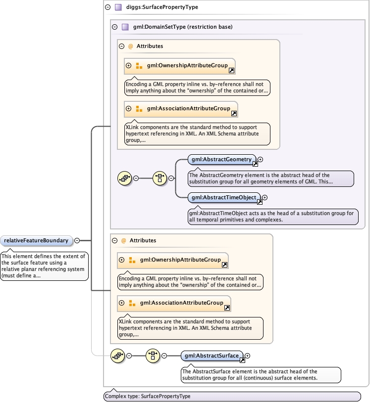
This element defines the extent of thesurface feature using a relative planar referencingsystem (must define a LocalcCartesanCRS object. Eitherthis element, or featureExtent is required, and canbe optionally added if featureExtent isused.
The 'actuate' attribute is used to communicate the desired timing of traversal from the starting resource to the ending resource; it's value should be treated as follows:onLoad - traverse to the ending resource immediately on loading the starting resource onRequest - traverse from the starting resource to the ending resource only on a post-loading event triggered for this purpose other - behavior is unconstrained; examine other markup in link for hints none - behavior is unconstrained
The 'show' attribute is used to communicate the desired presentation of the ending resource on traversal from the starting resource; it's value should be treated as follows: new - load ending resource in a new window, frame, pane, or other presentation contextreplace - load the resource in the same window, frame, pane, or other presentation contextembed - load ending resource in place of the presentation of the starting resourceother - behavior is unconstrained; examine other markup in the link for hints none - behavior is unconstrained
<element name="relativeFeatureBoundary" type="diggs:SurfacePropertyType" maxOccurs="1" minOccurs="0"><annotation><documentation>This element defines the extent of the surface feature using a relative planar referencing system (must define a LocalcCartesanCRS object. Either this element, or featureExtent is required, and can be optionally added if featureExtent is used.</documentation></annotation></element>
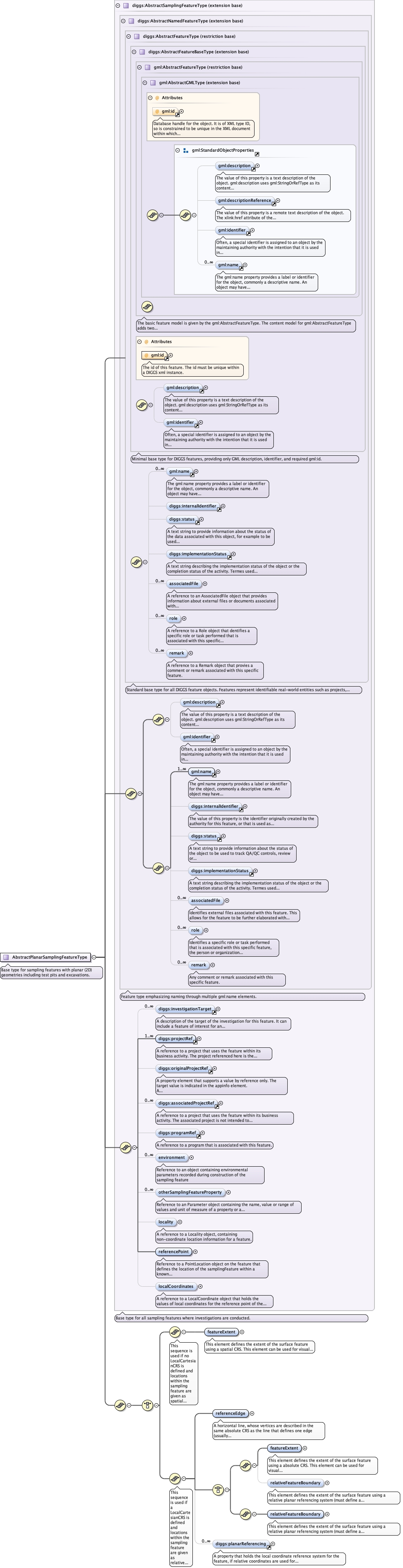
Complex Type diggs:AbstractPlanarSamplingFeatureType
Namespace
http://diggsml.org/schemas/3
Annotations
Base type for sampling features with planar (2D) geometries includingtest pits and excavations.
Database handle for the object. It is of XML type ID, so is constrained to beunique in the XML document within which it occurs. An external identifier for the object inthe form of a URI may be constructed using standard XML and XPointer methods. This is doneby concatenating the URI for the document, a fragment separator, and the value of the idattribute.
Source
<complexType name="AbstractPlanarSamplingFeatureType" abstract="true"><annotation><documentation>Base type for sampling features with planar (2D) geometries including test pits and excavations.</documentation></annotation><complexContent><extension base="diggs:AbstractSamplingFeatureType"><sequence><choice><sequence><annotation><documentation>This sequence is used if no LocalCartesianCRS is defined and locations within the sampling feature are given as spatial coordinates.</documentation></annotation><element name="featureExtent" type="diggs:SurfacePropertyType" maxOccurs="1" minOccurs="1"><annotation><documentation>This element defines the extent of the surface feature using a spatial CRS. This element can be used for visual representations using typical/simple mapping software. Either this element, or relativeFeatureExtent is required, and can be optionally added if relativeFeatureExtent is used.</documentation></annotation></element></sequence><sequence><annotation><documentation>This sequence is used if a LocalCartesianCRS is defined and locations within the sampling feature are given as relative coordinates.</documentation></annotation><element name="referenceEdge" type="diggs:LinearExtentPropertyType" minOccurs="1" maxOccurs="1"><annotation><documentation>A horizontal line, whose vertices are described in the same absolute CRS as the line that defines one edge (usually either the top or bottom edge)of the sampling feature’s surface. Where appropriate, this unit is used to represent the intersection of a 2D surface with the ground, or more commonly, when a single line (2 vertices only), is used to represent the x-axis of a 2D or 3D local CRS.</documentation></annotation></element><choice><sequence><element name="featureExtent" type="diggs:SurfacePropertyType" maxOccurs="1" minOccurs="1"><annotation><documentation>This element defines the extent of the surface feature using a absolute CRS. This element can be used for visual representations using typical/simple mapping software. Either this element, or relativeFeatureExtent is required, and can be optionally added if relativeFeatureExtent is used.</documentation></annotation></element><element name="relativeFeatureBoundary" type="diggs:SurfacePropertyType" maxOccurs="1" minOccurs="0"><annotation><documentation>This element defines the extent of the surface feature using a relative planar referencing system (must define a LocalcCartesanCRS object. Either this element, or featureExtent is required, and can be optionally added if featureExtent is used.</documentation></annotation></element></sequence><sequence><element name="relativeFeatureBoundary" type="diggs:SurfacePropertyType" maxOccurs="1" minOccurs="1"><annotation><documentation>This element defines the extent of the surface feature using a relative planar referencing system (must define a LocalCartesianCRS objec). This element should be used for software that can handle planar referencing. Either this element, or featureExtent is required, and can be optionally added if featureExtent is used.</documentation></annotation></element></sequence></choice><element ref="diggs:planarReferencing" maxOccurs="unbounded" minOccurs="0"/></sequence></choice></sequence></extension></complexContent></complexType>