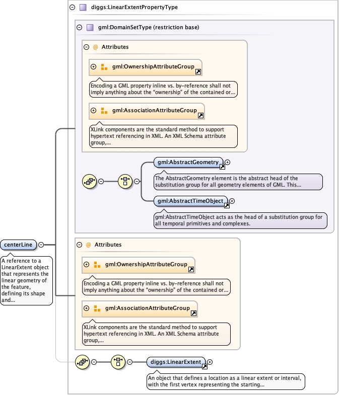
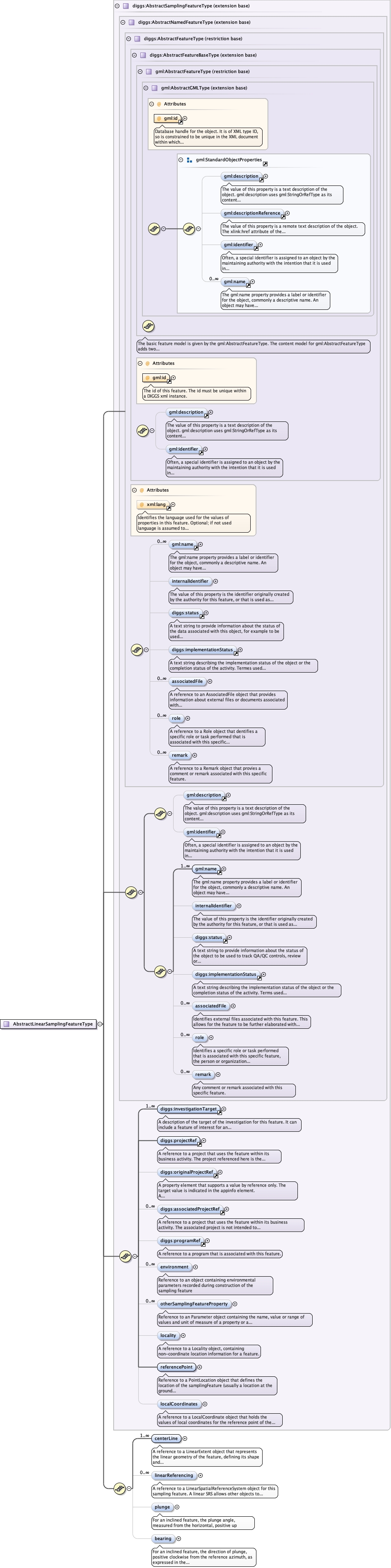
A reference to a LinearExtent object that represents thelinear geometry of the feature, defining its shape and location. Fora borehole for example, the linestring would represent theborehole's trajectory in 3D space. Multiple centerlines can bedefined (all associated with the same reference point) to definecomplex objects such as a wellbore with sidetracks, or differentreference datums for a single borehole.
The 'actuate' attribute is used to communicate the desired timing of traversal from the starting resource to the ending resource; it's value should be treated as follows:onLoad - traverse to the ending resource immediately on loading the starting resource onRequest - traverse from the starting resource to the ending resource only on a post-loading event triggered for this purpose other - behavior is unconstrained; examine other markup in link for hints none - behavior is unconstrained
The 'show' attribute is used to communicate the desired presentation of the ending resource on traversal from the starting resource; it's value should be treated as follows: new - load ending resource in a new window, frame, pane, or other presentation contextreplace - load the resource in the same window, frame, pane, or other presentation contextembed - load ending resource in place of the presentation of the starting resourceother - behavior is unconstrained; examine other markup in the link for hints none - behavior is unconstrained
<element name="centerLine" type="diggs:LinearExtentPropertyType" maxOccurs="unbounded" minOccurs="1"><annotation><documentation>A reference to a LinearExtent object that represents the linear geometry of the feature, defining its shape and location. For a borehole for example, the linestring would represent the borehole's trajectory in 3D space. Multiple centerlines can be defined (all associated with the same reference point) to define complex objects such as a wellbore with sidetracks, or different reference datums for a single borehole.</documentation></annotation></element>
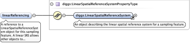
A reference to a LinearSpatialReferenceSystem object forthis sampling feature. A linear SRS allows other objects toreference their position (location) on the sampling feature with 1Dcoordinates that represents distance along the linear samplingfeature, typically from the centerline origin. For sampling featuressuch as boreholes the linear SRS coordinates define measured depthsdown the hole's centerline.
<element name="linearReferencing" type="diggs:LinearSpatialReferenceSystemPropertyType" minOccurs="0" maxOccurs="unbounded"><annotation><documentation>A reference to a LinearSpatialReferenceSystem object for this sampling feature. A linear SRS allows other objects to reference their position (location) on the sampling feature with 1D coordinates that represents distance along the linear sampling feature, typically from the centerline origin. For sampling features such as boreholes the linear SRS coordinates define measured depths down the hole's centerline.</documentation></annotation></element>
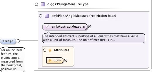
<element minOccurs="0" name="plunge" type="diggs:PlungeMeasureType"><annotation><documentation>For an inclined feature, the plunge angle, measured from the horizontal, positive up</documentation></annotation></element>
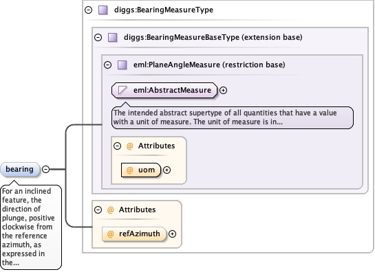
<element minOccurs="0" name="bearing" type="diggs:BearingMeasureType"><annotation><documentation>For an inclined feature, the direction of plunge, positive clockwise from the reference azimuth, as expressed in the refAzimuth attribute.</documentation></annotation></element>
Complex Type diggs:AbstractLinearSamplingFeatureType
Database handle for the object. It is of XML type ID, so is constrained to beunique in the XML document within which it occurs. An external identifier for the object inthe form of a URI may be constructed using standard XML and XPointer methods. This is doneby concatenating the URI for the document, a fragment separator, and the value of the idattribute.
<div><h3>lang (as an attribute name)</h3><p>denotes an attribute whose value is a language code for the natural language of the content of any element; its value is inherited. This name is reserved by virtue of its definition in the XML specification.</p></div><div><h4>Notes</h4><p>Attempting to install the relevant ISO 2- and 3-letter codes as the enumerated possible values is probably never going to be a realistic possibility.</p><p>See BCP 47 at<a href="http://www.rfc-editor.org/rfc/bcp/bcp47.txt">http://www.rfc-editor.org/rfc/bcp/bcp47.txt</a>and the IANA language subtag registry at<a href="http://www.iana.org/assignments/language-subtag-registry">http://www.iana.org/assignments/language-subtag-registry</a>for further information.</p><p>The union allows for the 'un-declaration' of xml:lang with the empty string.</p></div>
Source
<complexType name="AbstractLinearSamplingFeatureType"><complexContent><extension base="diggs:AbstractSamplingFeatureType"><sequence><element name="centerLine" type="diggs:LinearExtentPropertyType" maxOccurs="unbounded" minOccurs="1"><annotation><documentation>A reference to a LinearExtent object that represents the linear geometry of the feature, defining its shape and location. For a borehole for example, the linestring would represent the borehole's trajectory in 3D space. Multiple centerlines can be defined (all associated with the same reference point) to define complex objects such as a wellbore with sidetracks, or different reference datums for a single borehole.</documentation></annotation></element><element name="linearReferencing" type="diggs:LinearSpatialReferenceSystemPropertyType" minOccurs="0" maxOccurs="unbounded"><annotation><documentation>A reference to a LinearSpatialReferenceSystem object for this sampling feature. A linear SRS allows other objects to reference their position (location) on the sampling feature with 1D coordinates that represents distance along the linear sampling feature, typically from the centerline origin. For sampling features such as boreholes the linear SRS coordinates define measured depths down the hole's centerline.</documentation></annotation></element><element minOccurs="0" name="plunge" type="diggs:PlungeMeasureType"><annotation><documentation>For an inclined feature, the plunge angle, measured from the horizontal, positive up</documentation></annotation></element><element minOccurs="0" name="bearing" type="diggs:BearingMeasureType"><annotation><documentation>For an inclined feature, the direction of plunge, positive clockwise from the reference azimuth, as expressed in the refAzimuth attribute.</documentation></annotation></element></sequence></extension></complexContent></complexType>