Showing:

Annotations
Attributes
Diagrams
Instances
Model
Properties
Source
Used by
Element diggs:PlanarObservationRepresentationType / diggs:layerTopIntersection
Namespace http://diggsml.org/schemas/3
Annotations
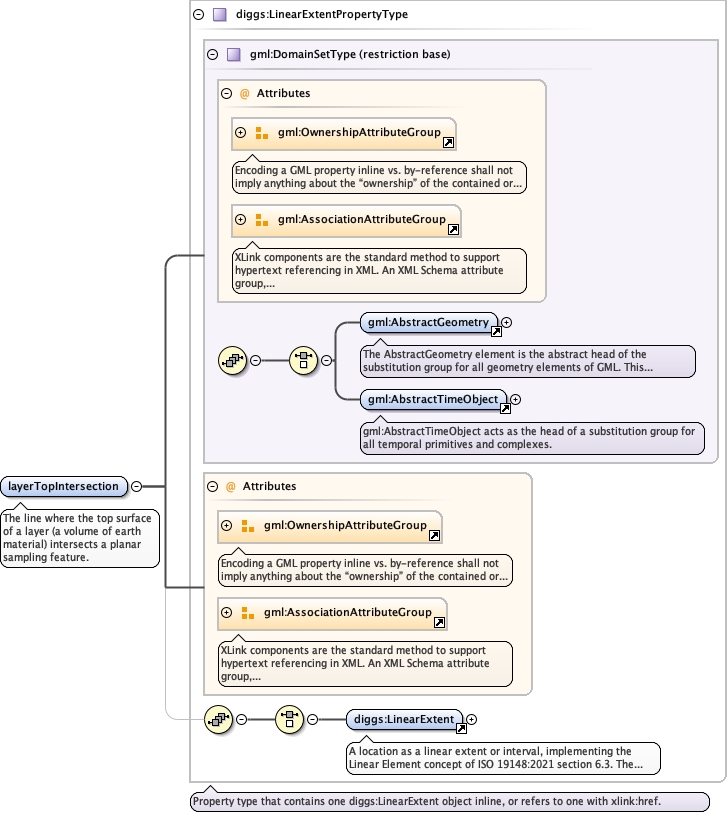
The line where the top surface of a layer (a volume of earth
material) intersects a planar sampling feature.
Diagram
Diagramgml3_2Profile_diggs_xsd_Attribute_Group_gml_OwnershipAttributeGroup.tmp#OwnershipAttributeGroupgml3_2Profile_diggs_xsd_Attribute_Group_gml_AssociationAttributeGroup.tmp#AssociationAttributeGroupgml3_2Profile_diggs_xsd_Element_gml_AbstractGeometry.tmp#AbstractGeometrygml3_2Profile_diggs_xsd_Element_gml_AbstractTimeObject.tmp#AbstractTimeObjectgml3_2Profile_diggs_xsd_Complex_Type_gml_DomainSetType.tmp#DomainSetTypegml3_2Profile_diggs_xsd_Attribute_Group_gml_OwnershipAttributeGroup.tmp#OwnershipAttributeGroupgml3_2Profile_diggs_xsd_Attribute_Group_gml_AssociationAttributeGroup.tmp#AssociationAttributeGroupCore_xsd_Element_diggs_LinearExtent.tmp#LinearExtentCore_xsd_Complex_Type_diggs_LinearExtentPropertyType.tmp#LinearExtentPropertyType
Type diggs:LinearExtentPropertyType
Type hierarchy
Properties
content complex
Model
Children diggs:LinearExtent
Instance
<diggs:layerTopIntersection owns="false" xlink:href="" nilReason="" xmlns:diggs="http://diggsml.org/schemas/3">
  <diggs:LinearExtent axisLabels="" gml:id="" srsDimension="" srsName="" uomLabels="">{1,1}</diggs:LinearExtent>
</diggs:layerTopIntersection>
Attributes
QName Type Default Use
nilReason gml:NilReasonType optional
owns boolean false optional
xlink:href anyURI optional
Source
<element name="layerTopIntersection" type="diggs:LinearExtentPropertyType">
  <annotation>
    <documentation>The line where the top surface of a layer (a volume of earth material) intersects a planar sampling feature.</documentation>
  </annotation>
</element>
Element diggs:PlanarObservationRepresentationType / diggs:layerBaseIntersection
Namespace http://diggsml.org/schemas/3
Annotations
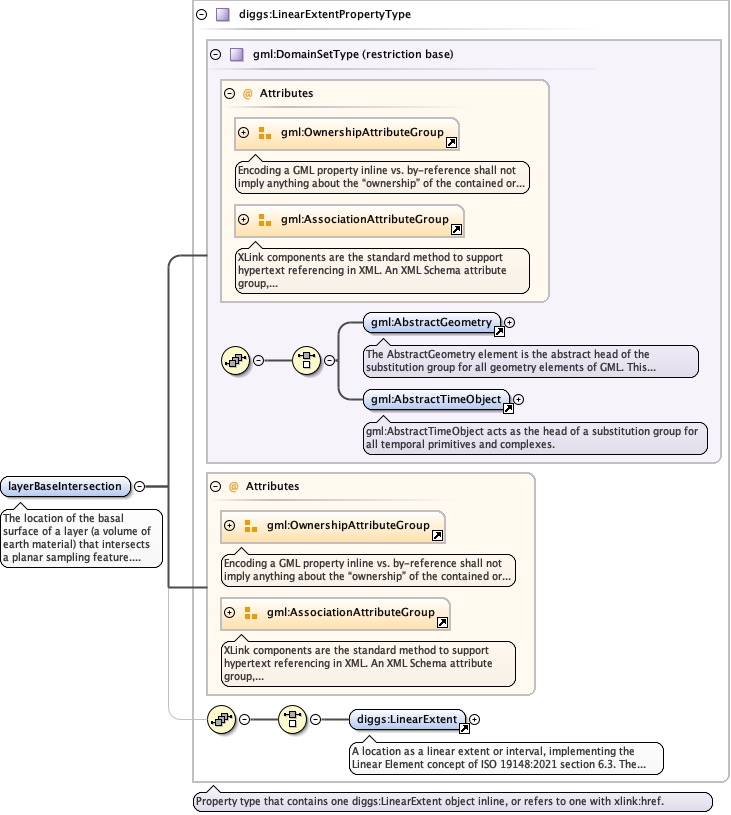
The location of the basal surface of a layer (a volume of earth
material) that intersects a planar sampling feature. Depending on
how the planar sampling feature is encoded, several line strings may
define this basal surface.
Diagram
Diagramgml3_2Profile_diggs_xsd_Attribute_Group_gml_OwnershipAttributeGroup.tmp#OwnershipAttributeGroupgml3_2Profile_diggs_xsd_Attribute_Group_gml_AssociationAttributeGroup.tmp#AssociationAttributeGroupgml3_2Profile_diggs_xsd_Element_gml_AbstractGeometry.tmp#AbstractGeometrygml3_2Profile_diggs_xsd_Element_gml_AbstractTimeObject.tmp#AbstractTimeObjectgml3_2Profile_diggs_xsd_Complex_Type_gml_DomainSetType.tmp#DomainSetTypegml3_2Profile_diggs_xsd_Attribute_Group_gml_OwnershipAttributeGroup.tmp#OwnershipAttributeGroupgml3_2Profile_diggs_xsd_Attribute_Group_gml_AssociationAttributeGroup.tmp#AssociationAttributeGroupCore_xsd_Element_diggs_LinearExtent.tmp#LinearExtentCore_xsd_Complex_Type_diggs_LinearExtentPropertyType.tmp#LinearExtentPropertyType
Type diggs:LinearExtentPropertyType
Type hierarchy
Properties
content complex
Model
Children diggs:LinearExtent
Instance
<diggs:layerBaseIntersection owns="false" xlink:href="" nilReason="" xmlns:diggs="http://diggsml.org/schemas/3">
  <diggs:LinearExtent axisLabels="" gml:id="" srsDimension="" srsName="" uomLabels="">{1,1}</diggs:LinearExtent>
</diggs:layerBaseIntersection>
Attributes
QName Type Default Use
nilReason gml:NilReasonType optional
owns boolean false optional
xlink:href anyURI optional
Source
<element name="layerBaseIntersection" type="diggs:LinearExtentPropertyType">
  <annotation>
    <documentation>The location of the basal surface of a layer (a volume of earth material) that intersects a planar sampling feature. Depending on how the planar sampling feature is encoded, several line strings may define this basal surface.</documentation>
  </annotation>
</element>
Element diggs:PlanarObservationRepresentationType / diggs:representativeSurface
Namespace http://diggsml.org/schemas/3
Annotations
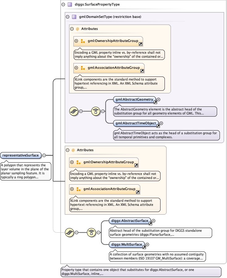
A polygon that represents the layer volume in the plane of the
planar sampling feature. It is typically a ring polygon whose curve
members are the layer top intersection, the layer bottom
intersection and two edges normally at the lateral extent of the
planar feature. Repeat for each polygon.
Diagram
Diagramgml3_2Profile_diggs_xsd_Attribute_Group_gml_OwnershipAttributeGroup.tmp#OwnershipAttributeGroupgml3_2Profile_diggs_xsd_Attribute_Group_gml_AssociationAttributeGroup.tmp#AssociationAttributeGroupgml3_2Profile_diggs_xsd_Element_gml_AbstractGeometry.tmp#AbstractGeometrygml3_2Profile_diggs_xsd_Element_gml_AbstractTimeObject.tmp#AbstractTimeObjectgml3_2Profile_diggs_xsd_Complex_Type_gml_DomainSetType.tmp#DomainSetTypegml3_2Profile_diggs_xsd_Attribute_Group_gml_OwnershipAttributeGroup.tmp#OwnershipAttributeGroupgml3_2Profile_diggs_xsd_Attribute_Group_gml_AssociationAttributeGroup.tmp#AssociationAttributeGroupAbstractTypes_xsd_Element_diggs_AbstractSurface.tmp#http___diggsml.org_schemas_3_AbstractSurfaceCore_xsd_Element_diggs_MultiSurface.tmp#MultiSurfaceCore_xsd_Complex_Type_diggs_SurfacePropertyType.tmp#SurfacePropertyType
Type diggs:SurfacePropertyType
Type hierarchy
Properties
content complex
maxOccurs unbounded
Model
Children diggs:AbstractSurface, diggs:MultiSurface
Instance
<diggs:representativeSurface owns="false" xlink:href="" nilReason="" xmlns:diggs="http://diggsml.org/schemas/3">
  <diggs:AbstractSurface axisLabels="" gml:id="" srsDimension="" srsName="" uomLabels="">{1,1}</diggs:AbstractSurface>
  <diggs:MultiSurface aggregationType="" axisLabels="" gml:id="" srsDimension="" srsName="" uomLabels="">{1,1}</diggs:MultiSurface>
</diggs:representativeSurface>
Attributes
QName Type Default Use
nilReason gml:NilReasonType optional
owns boolean false optional
xlink:href anyURI optional
Source
<element maxOccurs="unbounded" name="representativeSurface" type="diggs:SurfacePropertyType">
  <annotation>
    <documentation>A polygon that represents the layer volume in the plane of the planar sampling feature. It is typically a ring polygon whose curve members are the layer top intersection, the layer bottom intersection and two edges normally at the lateral extent of the planar feature. Repeat for each polygon.</documentation>
  </annotation>
</element>
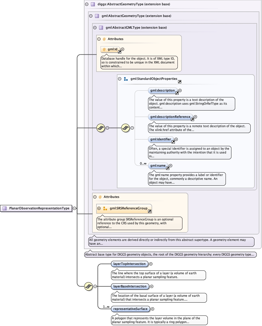
Complex Type diggs:PlanarObservationRepresentationType
Namespace http://diggsml.org/schemas/3
Diagram
Diagramgml3_2Profile_diggs_xsd_Attribute_gml_id.tmp#idgml3_2Profile_diggs_xsd_Element_gml_description.tmp#descriptiongml3_2Profile_diggs_xsd_Element_gml_descriptionReference.tmp#descriptionReferencegml3_2Profile_diggs_xsd_Element_gml_identifier.tmp#identifiergml3_2Profile_diggs_xsd_Element_gml_name.tmp#namegml3_2Profile_diggs_xsd_Element_Group_gml_StandardObjectProperties.tmp#StandardObjectPropertiesgml3_2Profile_diggs_xsd_Complex_Type_gml_AbstractGMLType.tmp#AbstractGMLTypegml3_2Profile_diggs_xsd_Attribute_Group_gml_SRSReferenceGroup.tmp#SRSReferenceGroupgml3_2Profile_diggs_xsd_Complex_Type_gml_AbstractGeometryType.tmp#AbstractGeometryTypeCore_xsd_Complex_Type_diggs_AbstractGeometryType.tmp#http___diggsml.org_schemas_3_AbstractGeometryTypeExtSamplingFeatures_xsd_Complex_Type_diggs_PlanarObservationRepresentationType.tmp#PlanarObservationRepresentationType_layerTopIntersectionExtSamplingFeatures_xsd_Complex_Type_diggs_PlanarObservationRepresentationType.tmp#PlanarObservationRepresentationType_layerBaseIntersectionExtSamplingFeatures_xsd_Complex_Type_diggs_PlanarObservationRepresentationType.tmp#PlanarObservationRepresentationType_representativeSurface
Type extension of diggs:AbstractGeometryType
Type hierarchy
Used by
Model
Children diggs:layerBaseIntersection, diggs:layerTopIntersection, diggs:representativeSurface, gml:description, gml:descriptionReference, gml:identifier, gml:name
Attributes
QName Type Use Annotation
axisLabels gml:NCNameList optional
gml:id ID optional
Database handle for the object. It is of XML type ID, so is constrained to be
unique in the XML document within which it occurs. An external identifier for the object in
the form of a URI may be constructed using standard XML and XPointer methods. This is done
by concatenating the URI for the document, a fragment separator, and the value of the id
attribute.
srsDimension positiveInteger optional
srsName anyURI optional
uomLabels gml:NCNameList optional
Source
<complexType name="PlanarObservationRepresentationType">
  <complexContent>
    <extension base="diggs:AbstractGeometryType">
      <sequence>
        <element name="layerTopIntersection" type="diggs:LinearExtentPropertyType">
          <annotation>
            <documentation>The line where the top surface of a layer (a volume of earth material) intersects a planar sampling feature.</documentation>
          </annotation>
        </element>
        <element name="layerBaseIntersection" type="diggs:LinearExtentPropertyType">
          <annotation>
            <documentation>The location of the basal surface of a layer (a volume of earth material) that intersects a planar sampling feature. Depending on how the planar sampling feature is encoded, several line strings may define this basal surface.</documentation>
          </annotation>
        </element>
        <element maxOccurs="unbounded" name="representativeSurface" type="diggs:SurfacePropertyType">
          <annotation>
            <documentation>A polygon that represents the layer volume in the plane of the planar sampling feature. It is typically a ring polygon whose curve members are the layer top intersection, the layer bottom intersection and two edges normally at the lateral extent of the planar feature. Repeat for each polygon.</documentation>
          </annotation>
        </element>
      </sequence>
    </extension>
  </complexContent>
</complexType>