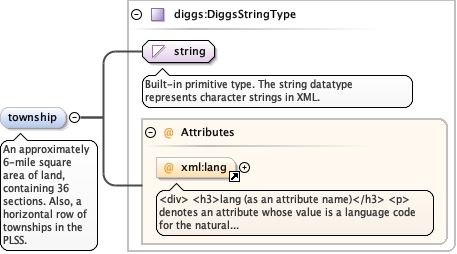
<div><h3>lang (as an attribute name)</h3><p>denotes an attribute whose value is a language code for the natural language of the content of any element; its value is inherited. This name is reserved by virtue of its definition in the XML specification.</p></div><div><h4>Notes</h4><p>Attempting to install the relevant ISO 2- and 3-letter codes as the enumerated possible values is probably never going to be a realistic possibility.</p><p>See BCP 47 at<a href="http://www.rfc-editor.org/rfc/bcp/bcp47.txt">http://www.rfc-editor.org/rfc/bcp/bcp47.txt</a>and the IANA language subtag registry at<a href="http://www.iana.org/assignments/language-subtag-registry">http://www.iana.org/assignments/language-subtag-registry</a>for further information.</p><p>The union allows for the 'un-declaration' of xml:lang with the empty string.</p></div>
Source
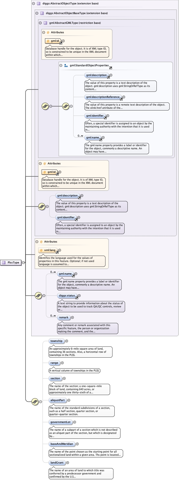
<element name="township" type="diggs:DiggsStringType" minOccurs="0" maxOccurs="1"><annotation><documentation>An approximately 6-mile square area of land, containing 36 sections. Also, a horizontal row of townships in the PLSS.</documentation></annotation></element>
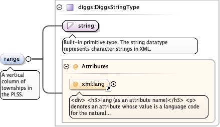
<div><h3>lang (as an attribute name)</h3><p>denotes an attribute whose value is a language code for the natural language of the content of any element; its value is inherited. This name is reserved by virtue of its definition in the XML specification.</p></div><div><h4>Notes</h4><p>Attempting to install the relevant ISO 2- and 3-letter codes as the enumerated possible values is probably never going to be a realistic possibility.</p><p>See BCP 47 at<a href="http://www.rfc-editor.org/rfc/bcp/bcp47.txt">http://www.rfc-editor.org/rfc/bcp/bcp47.txt</a>and the IANA language subtag registry at<a href="http://www.iana.org/assignments/language-subtag-registry">http://www.iana.org/assignments/language-subtag-registry</a>for further information.</p><p>The union allows for the 'un-declaration' of xml:lang with the empty string.</p></div>
Source
<element name="range" type="diggs:DiggsStringType" minOccurs="0" maxOccurs="1"><annotation><documentation>A vertical column of townships in the PLSS.</documentation></annotation></element>
The name of the section; a one-square-mile block of land,containing 640 acres, or approximately one thirty-sixth of atownship. Due to the curvature of the Earth, sections mayoccasionally be slightly smaller than one squaremile.
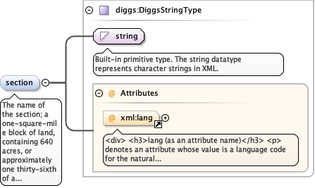
<div><h3>lang (as an attribute name)</h3><p>denotes an attribute whose value is a language code for the natural language of the content of any element; its value is inherited. This name is reserved by virtue of its definition in the XML specification.</p></div><div><h4>Notes</h4><p>Attempting to install the relevant ISO 2- and 3-letter codes as the enumerated possible values is probably never going to be a realistic possibility.</p><p>See BCP 47 at<a href="http://www.rfc-editor.org/rfc/bcp/bcp47.txt">http://www.rfc-editor.org/rfc/bcp/bcp47.txt</a>and the IANA language subtag registry at<a href="http://www.iana.org/assignments/language-subtag-registry">http://www.iana.org/assignments/language-subtag-registry</a>for further information.</p><p>The union allows for the 'un-declaration' of xml:lang with the empty string.</p></div>
Source
<element name="section" type="diggs:DiggsStringType" minOccurs="0" maxOccurs="1"><annotation><documentation>The name of the section; a one-square-mile block of land, containing 640 acres, or approximately one thirty-sixth of a township. Due to the curvature of the Earth, sections may occasionally be slightly smaller than one square mile.</documentation></annotation></element>
<div><h3>lang (as an attribute name)</h3><p>denotes an attribute whose value is a language code for the natural language of the content of any element; its value is inherited. This name is reserved by virtue of its definition in the XML specification.</p></div><div><h4>Notes</h4><p>Attempting to install the relevant ISO 2- and 3-letter codes as the enumerated possible values is probably never going to be a realistic possibility.</p><p>See BCP 47 at<a href="http://www.rfc-editor.org/rfc/bcp/bcp47.txt">http://www.rfc-editor.org/rfc/bcp/bcp47.txt</a>and the IANA language subtag registry at<a href="http://www.iana.org/assignments/language-subtag-registry">http://www.iana.org/assignments/language-subtag-registry</a>for further information.</p><p>The union allows for the 'un-declaration' of xml:lang with the empty string.</p></div>
Source
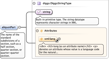
<element minOccurs="0" name="aliquotPart" type="diggs:DiggsStringType"><annotation><documentation>The name of the standard subdivisions of a section, such as a half section, quarter section, or quarter-quarter section.</documentation></annotation></element>
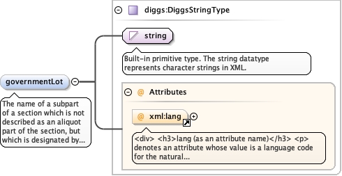
The name of a subpart of a section which is not describedas an aliquot part of the section, but which is designated bynumber, for example, Lot 3. A lot may be regular or irregular inshape, and its acreage may vary from that of regular aliquot parts.These lots frequently border water areas excluded from thePLSS.
<div><h3>lang (as an attribute name)</h3><p>denotes an attribute whose value is a language code for the natural language of the content of any element; its value is inherited. This name is reserved by virtue of its definition in the XML specification.</p></div><div><h4>Notes</h4><p>Attempting to install the relevant ISO 2- and 3-letter codes as the enumerated possible values is probably never going to be a realistic possibility.</p><p>See BCP 47 at<a href="http://www.rfc-editor.org/rfc/bcp/bcp47.txt">http://www.rfc-editor.org/rfc/bcp/bcp47.txt</a>and the IANA language subtag registry at<a href="http://www.iana.org/assignments/language-subtag-registry">http://www.iana.org/assignments/language-subtag-registry</a>for further information.</p><p>The union allows for the 'un-declaration' of xml:lang with the empty string.</p></div>
Source
<element minOccurs="0" name="governmentLot" type="diggs:DiggsStringType"><annotation><documentation>The name of a subpart of a section which is not described as an aliquot part of the section, but which is designated by number, for example, Lot 3. A lot may be regular or irregular in shape, and its acreage may vary from that of regular aliquot parts. These lots frequently border water areas excluded from the PLSS.</documentation></annotation></element>
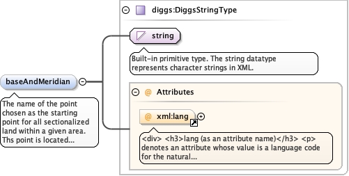
The name of the point chosen as the starting point forall sectionalized land within a given area. Ths point is located atthe intersection of a base line (parallel of latitude, orapproximately a parallel of latitude), and a principalmeridian.
<div><h3>lang (as an attribute name)</h3><p>denotes an attribute whose value is a language code for the natural language of the content of any element; its value is inherited. This name is reserved by virtue of its definition in the XML specification.</p></div><div><h4>Notes</h4><p>Attempting to install the relevant ISO 2- and 3-letter codes as the enumerated possible values is probably never going to be a realistic possibility.</p><p>See BCP 47 at<a href="http://www.rfc-editor.org/rfc/bcp/bcp47.txt">http://www.rfc-editor.org/rfc/bcp/bcp47.txt</a>and the IANA language subtag registry at<a href="http://www.iana.org/assignments/language-subtag-registry">http://www.iana.org/assignments/language-subtag-registry</a>for further information.</p><p>The union allows for the 'un-declaration' of xml:lang with the empty string.</p></div>
Source
<element minOccurs="0" name="baseAndMeridian" type="diggs:DiggsStringType"><annotation><documentation>The name of the point chosen as the starting point for all sectionalized land within a given area. Ths point is located at the intersection of a base line (parallel of latitude, or approximately a parallel of latitude), and a principal meridian.</documentation></annotation></element>
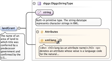
The name of an area of land to which title was conferredby a predecessor government and confirmed by the U.S Governmentafter the territory in which it is situated was acquired by theUnited States. These lands were never part of the original publicdomain and were not subject to subdivision by thePLSS.
<div><h3>lang (as an attribute name)</h3><p>denotes an attribute whose value is a language code for the natural language of the content of any element; its value is inherited. This name is reserved by virtue of its definition in the XML specification.</p></div><div><h4>Notes</h4><p>Attempting to install the relevant ISO 2- and 3-letter codes as the enumerated possible values is probably never going to be a realistic possibility.</p><p>See BCP 47 at<a href="http://www.rfc-editor.org/rfc/bcp/bcp47.txt">http://www.rfc-editor.org/rfc/bcp/bcp47.txt</a>and the IANA language subtag registry at<a href="http://www.iana.org/assignments/language-subtag-registry">http://www.iana.org/assignments/language-subtag-registry</a>for further information.</p><p>The union allows for the 'un-declaration' of xml:lang with the empty string.</p></div>
Source
<element minOccurs="0" name="landGrant" type="diggs:DiggsStringType"><annotation><documentation>The name of an area of land to which title was conferred by a predecessor government and confirmed by the U.S Government after the territory in which it is situated was acquired by the United States. These lands were never part of the original public domain and were not subject to subdivision by the PLSS.</documentation></annotation></element>
Database handle for the object. It is of XML type ID, so is constrained to beunique in the XML document within which it occurs. An external identifier for the object inthe form of a URI may be constructed using standard XML and XPointer methods. This is doneby concatenating the URI for the document, a fragment separator, and the value of the idattribute.
<div><h3>lang (as an attribute name)</h3><p>denotes an attribute whose value is a language code for the natural language of the content of any element; its value is inherited. This name is reserved by virtue of its definition in the XML specification.</p></div><div><h4>Notes</h4><p>Attempting to install the relevant ISO 2- and 3-letter codes as the enumerated possible values is probably never going to be a realistic possibility.</p><p>See BCP 47 at<a href="http://www.rfc-editor.org/rfc/bcp/bcp47.txt">http://www.rfc-editor.org/rfc/bcp/bcp47.txt</a>and the IANA language subtag registry at<a href="http://www.iana.org/assignments/language-subtag-registry">http://www.iana.org/assignments/language-subtag-registry</a>for further information.</p><p>The union allows for the 'un-declaration' of xml:lang with the empty string.</p></div>
Source
<complexType name="PlssType"><complexContent><extension base="diggs:AbstractObjectType"><sequence><element name="township" type="diggs:DiggsStringType" minOccurs="0" maxOccurs="1"><annotation><documentation>An approximately 6-mile square area of land, containing 36 sections. Also, a horizontal row of townships in the PLSS.</documentation></annotation></element><element name="range" type="diggs:DiggsStringType" minOccurs="0" maxOccurs="1"><annotation><documentation>A vertical column of townships in the PLSS.</documentation></annotation></element><element name="section" type="diggs:DiggsStringType" minOccurs="0" maxOccurs="1"><annotation><documentation>The name of the section; a one-square-mile block of land, containing 640 acres, or approximately one thirty-sixth of a township. Due to the curvature of the Earth, sections may occasionally be slightly smaller than one square mile.</documentation></annotation></element><element minOccurs="0" name="aliquotPart" type="diggs:DiggsStringType"><annotation><documentation>The name of the standard subdivisions of a section, such as a half section, quarter section, or quarter-quarter section.</documentation></annotation></element><element minOccurs="0" name="governmentLot" type="diggs:DiggsStringType"><annotation><documentation>The name of a subpart of a section which is not described as an aliquot part of the section, but which is designated by number, for example, Lot 3. A lot may be regular or irregular in shape, and its acreage may vary from that of regular aliquot parts. These lots frequently border water areas excluded from the PLSS.</documentation></annotation></element><element minOccurs="0" name="baseAndMeridian" type="diggs:DiggsStringType"><annotation><documentation>The name of the point chosen as the starting point for all sectionalized land within a given area. Ths point is located at the intersection of a base line (parallel of latitude, or approximately a parallel of latitude), and a principal meridian.</documentation></annotation></element><element minOccurs="0" name="landGrant" type="diggs:DiggsStringType"><annotation><documentation>The name of an area of land to which title was conferred by a predecessor government and confirmed by the U.S Government after the territory in which it is situated was acquired by the United States. These lands were never part of the original public domain and were not subject to subdivision by the PLSS.</documentation></annotation></element></sequence></extension></complexContent></complexType>