| Namespace | http://diggsml.org/schema-dev | ||||||||||||||||||||||||||||||||||||||||||||||||||||||||||||
|
Annotations
|
|
||||||||||||||||||||||||||||||||||||||||||||||||||||||||||||
|
Diagram
|
 |
||||||||||||||||||||||||||||||||||||||||||||||||||||||||||||
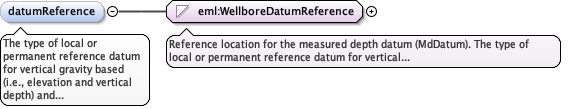
| Type | eml:WellboreDatumReference | ||||||||||||||||||||||||||||||||||||||||||||||||||||||||||||
| Type hierarchy | |||||||||||||||||||||||||||||||||||||||||||||||||||||||||||||
|
Properties
|
|
||||||||||||||||||||||||||||||||||||||||||||||||||||||||||||
|
Facets
|
|
||||||||||||||||||||||||||||||||||||||||||||||||||||||||||||
|
Source
|
|