Provides a fully qualified gml:identifier value of the targetfeature. Used primarily to reference a feature by a globally uniqueidentifier as opposed to the gml:id
The 'actuate' attribute is used to communicate the desired timing of traversal from the starting resource to the ending resource; it's value should be treated as follows:onLoad - traverse to the ending resource immediately on loading the starting resource onRequest - traverse from the starting resource to the ending resource only on a post-loading event triggered for this purpose other - behavior is unconstrained; examine other markup in link for hints none - behavior is unconstrained
The 'show' attribute is used to communicate the desired presentation of the ending resource on traversal from the starting resource; it's value should be treated as follows: new - load ending resource in a new window, frame, pane, or other presentation contextreplace - load the resource in the same window, frame, pane, or other presentation contextembed - load ending resource in place of the presentation of the starting resourceother - behavior is unconstrained; examine other markup in the link for hints none - behavior is unconstrained
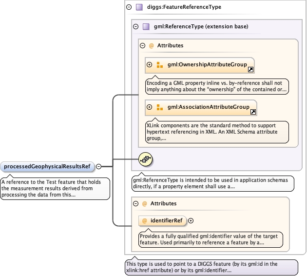
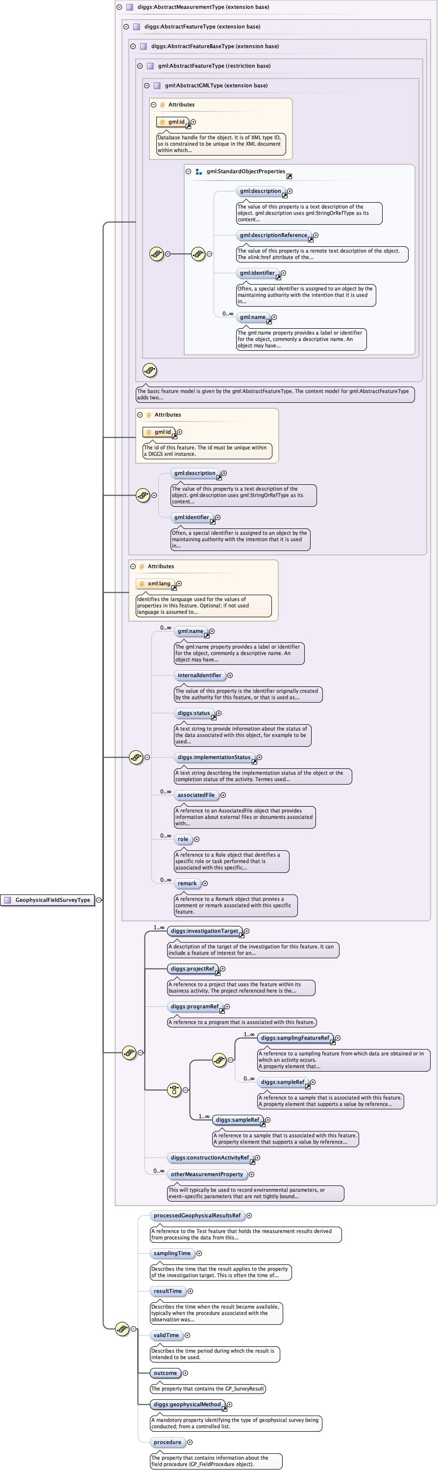
<element minOccurs="0" name="processedGeophysicalResultsRef" type="diggs:FeatureReferenceType"><annotation><documentation>A reference to the Test feature that holds the measurement results derived from processing the data from this geophysical field survey.</documentation></annotation></element>
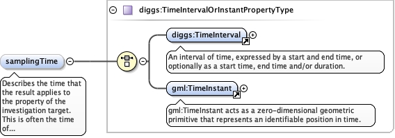
Describes the time that the result applies to theproperty of the investigation target. This is often the time ofinteraction by a sampling activity or measurement procedure with areal-world feature.
<element minOccurs="0" name="samplingTime" type="diggs:TimeIntervalOrInstantPropertyType"><annotation><documentation>Describes the time that the result applies to the property of the investigation target. This is often the time of interaction by a sampling activity or measurement procedure with a real-world feature.</documentation></annotation></element>
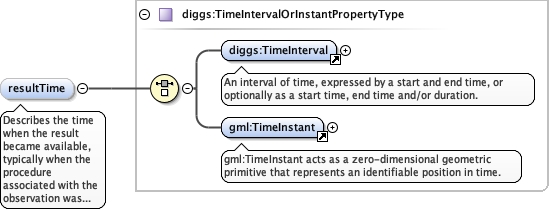
Describes the time when the result became available,typically when the procedure associated with the observation wascompleted. For some observations this is identical to thesamplingTime. However, there are important cases where they differ.Example: Where a measurement is made on a specimen in a laboratory,the samplingTime should record the time the specimen was retrievedfrom its host, while the resultTime should record the time thelaboratory procedure was applied. Example: Where monitoringobservation results are post-processed, the resultTime is thepost-processing time, while the samplingTime preserves the time ofinitial interaction with the world.
<element minOccurs="0" name="resultTime" type="diggs:TimeIntervalOrInstantPropertyType"><annotation><documentation>Describes the time when the result became available, typically when the procedure associated with the observation was completed. For some observations this is identical to the samplingTime. However, there are important cases where they differ. Example: Where a measurement is made on a specimen in a laboratory, the samplingTime should record the time the specimen was retrieved from its host, while the resultTime should record the time the laboratory procedure was applied. Example: Where monitoring observation results are post-processed, the resultTime is the post-processing time, while the samplingTime preserves the time of initial interaction with the world.</documentation></annotation></element>
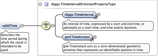
<element minOccurs="0" name="validTime" type="diggs:TimeIntervalOrInstantPropertyType"><annotation><documentation>Describes the time period during which the result is intended to be used.</documentation></annotation></element>
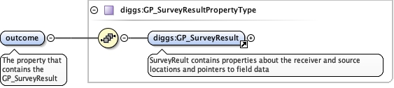
<element name="outcome" type="diggs:GP_SurveyResultPropertyType"><annotation><documentation>The property that contains the GP_SurveyResult</documentation></annotation></element>
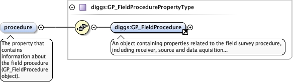
<element minOccurs="0" name="procedure" type="diggs:GP_FieldProcedurePropertyType"><annotation><documentation>The property that contains information about the field procedure (GP_FieldProcedure object).</documentation></annotation></element>
Database handle for the object. It is of XML type ID, so is constrained to beunique in the XML document within which it occurs. An external identifier for the object inthe form of a URI may be constructed using standard XML and XPointer methods. This is doneby concatenating the URI for the document, a fragment separator, and the value of the idattribute.
<div><h3>lang (as an attribute name)</h3><p>denotes an attribute whose value is a language code for the natural language of the content of any element; its value is inherited. This name is reserved by virtue of its definition in the XML specification.</p></div><div><h4>Notes</h4><p>Attempting to install the relevant ISO 2- and 3-letter codes as the enumerated possible values is probably never going to be a realistic possibility.</p><p>See BCP 47 at<a href="http://www.rfc-editor.org/rfc/bcp/bcp47.txt">http://www.rfc-editor.org/rfc/bcp/bcp47.txt</a>and the IANA language subtag registry at<a href="http://www.iana.org/assignments/language-subtag-registry">http://www.iana.org/assignments/language-subtag-registry</a>for further information.</p><p>The union allows for the 'un-declaration' of xml:lang with the empty string.</p></div>
Source
<complexType mixed="false" name="GeophysicalFieldSurveyType"><complexContent><extension base="diggs:AbstractMeasurementType"><sequence><element minOccurs="0" name="processedGeophysicalResultsRef" type="diggs:FeatureReferenceType"><annotation><documentation>A reference to the Test feature that holds the measurement results derived from processing the data from this geophysical field survey.</documentation></annotation></element><element minOccurs="0" name="samplingTime" type="diggs:TimeIntervalOrInstantPropertyType"><annotation><documentation>Describes the time that the result applies to the property of the investigation target. This is often the time of interaction by a sampling activity or measurement procedure with a real-world feature.</documentation></annotation></element><element minOccurs="0" name="resultTime" type="diggs:TimeIntervalOrInstantPropertyType"><annotation><documentation>Describes the time when the result became available, typically when the procedure associated with the observation was completed. For some observations this is identical to the samplingTime. However, there are important cases where they differ. Example: Where a measurement is made on a specimen in a laboratory, the samplingTime should record the time the specimen was retrieved from its host, while the resultTime should record the time the laboratory procedure was applied. Example: Where monitoring observation results are post-processed, the resultTime is the post-processing time, while the samplingTime preserves the time of initial interaction with the world.</documentation></annotation></element><element minOccurs="0" name="validTime" type="diggs:TimeIntervalOrInstantPropertyType"><annotation><documentation>Describes the time period during which the result is intended to be used.</documentation></annotation></element><element name="outcome" type="diggs:GP_SurveyResultPropertyType"><annotation><documentation>The property that contains the GP_SurveyResult</documentation></annotation></element><element ref="diggs:geophysicalMethod"><annotation><documentation>A mandotory property identifying the type of geophysical survey being conducted; from a controlled list.</documentation></annotation></element><element minOccurs="0" name="procedure" type="diggs:GP_FieldProcedurePropertyType"><annotation><documentation>The property that contains information about the field procedure (GP_FieldProcedure object).</documentation></annotation></element></sequence></extension></complexContent></complexType>