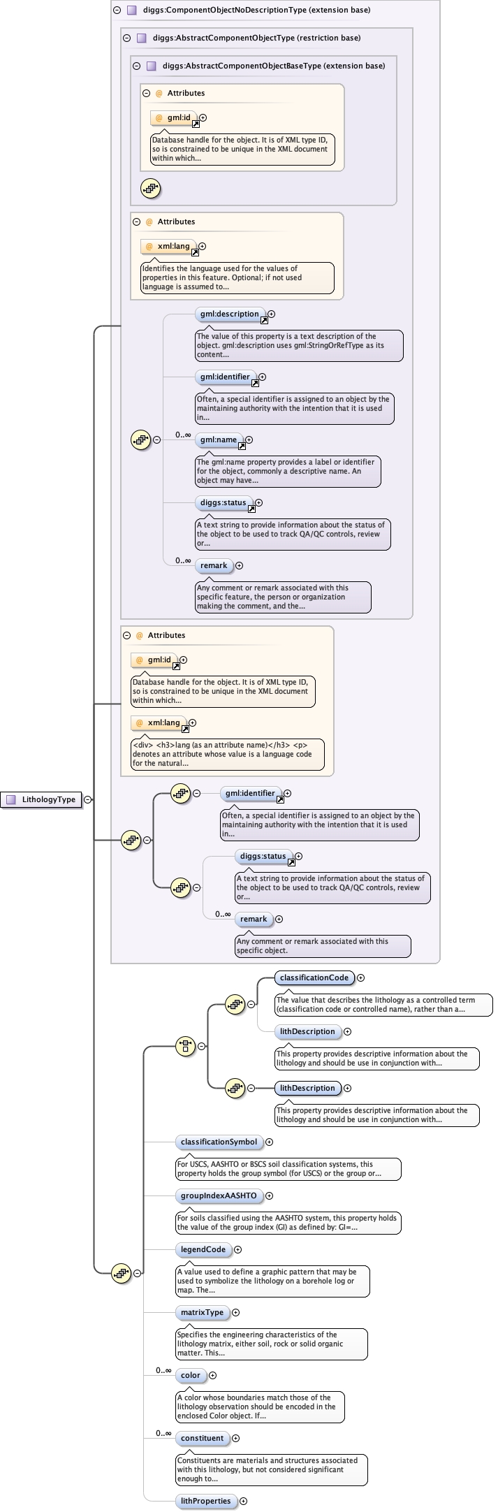
<complexType name="LithologyType" mixed="false">
<annotation>
<documentation/>
</annotation>
<complexContent>
<extension base="diggs:ComponentObjectNoDescriptionType">
<sequence>
<choice>
<sequence>
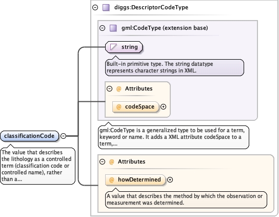
<element name="classificationCode" type="diggs:DescriptorCodeType" minOccurs="1" maxOccurs="1">
  <annotation>
    <documentation>The value that describes the lithology as a controlled term (classification code or controlled name), rather than a simply descriptive one. Examples: 1) For soils described using the Unified Soil Classification, this value shall be the "group name", including any modifiers as defined in Figures 1,2 and 3 of ASTM D2487 or Figures 1 and 2 of ASTM D2488, eg "Silty sand" or "Gravelly silt with sand". Where only the group symbol is reported, the unmodifed group name for the symbol should be used, as shown in Table 1 of ASTM D2487. 2) For soils described using the AASHTO soil classification system, this value should be the group or subgroup classification (eg. "A-3", "A-2-6"). 3) For soils classified using the USDA, Shepard (1954), or Folk classifications based on soil textures, this value would be the full-text textural classification, eg. "sandy loam" (USDA), "sand-silt-clay" (Shepard), or "muddy Sand" (Folk). 4) For soils classified using the British Soil Classification System, this value would be the recommended name (eg. "CLAY of very high plasticity"), or the group symbol if the standard name is not given (eg. "CV"). 5) For rock, for example as defined by the American Geosciences Institute (AGI) glossary, this value would be the rock name (eg. "Dolostone", "Basalt", "Pebbly mudstone", etc.). Either a classificationCode value or lithDescription value must be present in the Lithology object. The codespace attribute should be a URL to an xml dictionary that conforms to the GML Dictionary.xsd and DIGGSDictionary_diggs.xsd schemas and that defines the terms used in the classification system within diggs:Definition elements. The value of classificationCode should be equivalent to a gml:name property of the associated diggs:Definition, for example:
      <![CDATA[
    <classificationCode codespace="https://diggsml.org/def/codes/DIGGS/0.1/astmD2488.xml#SWg">Well-graded sand with gravel</classificationCode>]]>An example diggs:Definition element within the dictionary would look as follows:
      <![CDATA[

        <diggs:Definition gml:id="SWg">
            <gml:description>SW with ≥ 15% gravel</gml:description>
            <gml:identifier codeSpace="https://diggsml.org/def/authorities.xml#DIGGS">https://diggsml.org/def/codes/DIGGS/0.1/astmD2487.xml#SWg</gml:identifier>
            <gml:name>Well-graded sand with gravel</gml:name>
            <diggs:dataType>string</diggs:dataType>
            <diggs:authority>ASTM D2487</diggs:authority>
            <diggs:reference>https://www.astm.org/d2487-17.html</diggs:reference>
            <diggs:occurrences>
                <diggs:Occurrence>
                    <diggs:sourceElementXpath>//diggs:Lithology/diggs:classificationCode</diggs:sourceElementXpath>
                </diggs:Occurrence>
            </diggs:occurrences>
        </diggs:Definition>]]>The Geo-Institute has developed online dictionaries for ASTM D2487, ASTM D2488, AASHTO and USDA classification systems that should be referenced in instance documents that use those classifications. Classification systems that do not have an online dictionary may be used, but the codeSpace attribute should be a URL to an online resource for the classification system rather than an uncontrolled string value. Such usage may limit interoperability and is not recommended - a dictionary should be developed for these cases.</documentation>
  </annotation>
</element>
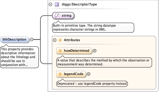
<element minOccurs="0" name="lithDescription" type="diggs:DescriptorType">
  <annotation>
    <documentation>This property provides descriptive information about the lithology and should be use in conjunction with classificationCode. If the information is recorded, lithDescription include a description of color,facies, grain size disctribution, constituents and field properties, even if those properties are not specifically encoded (eg. well-graded sand (SW), fine-grained, dark grey, massive, dry, hard). If the lithology description does not include any controlled term that serves to classify it, then lithDescription must be used instead of classificationCode, i.e., either classificationCode or lithDescription must contain a value (although both may contain values and is preferred).</documentation>
  </annotation>
</element>
</sequence>
<sequence>
<element minOccurs="1" name="lithDescription" type="diggs:DescriptorType">
<annotation>
<documentation>This property provides descriptive information about the lithology and should be use in conjunction with classificationCode. If the information is recorded, lithDescription include a description of color,facies, grain size disctribution, constituents and field properties, even if those properties are not specifically encoded (eg. well-graded sand (SW), fine-grained, dark grey, massive, dry, hard). If the lithology description does not include any controlled term that serves to classify it, then lithDescription must be used instead of classificationCode, i.e., either classificationCode or lithDescription must contain a value (although both may contain values and is preferred).</documentation>
</annotation>
</element>
</sequence>
</choice>
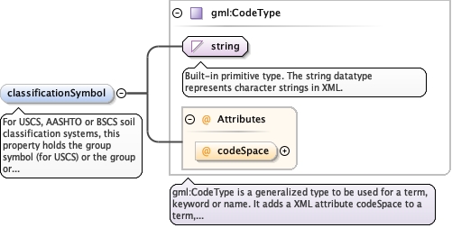
<element minOccurs="0" name="classificationSymbol" maxOccurs="1" type="gml:CodeType">
  <annotation>
    <documentation>For USCS, AASHTO or BSCS soil classification systems, this property holds the group symbol (for USCS) or the group or appropriate subgroup classification (for AASHTO and BSCS). Symbology for nan-standard or proprietary classifications may also be reported here. Codespace attribute is mandatory and should preferably a link to the associated DIGGS dictionary, or be either USCS, AASHTO, or BSCS for those systems, or an authority code for non-standard systems.</documentation>
  </annotation>
</element>
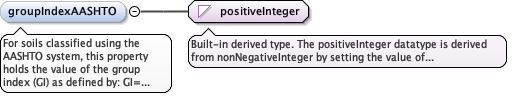
<element minOccurs="0" name="groupIndexAASHTO" type="positiveInteger">
  <annotation>
    <documentation>For soils classified using the AASHTO system, this property holds the value of the group index (GI) as defined by: GI= (F–35)[0.2+0.005(LL– 40)}+(F–15)(PI–10) where F is the percentage passing the 75 μm (0.075 mm) sieve, expressed as a whole number, LL is the liquid limit and PI is the plasticity index.</documentation>
  </annotation>
</element>
<element minOccurs="0" name="legendCode" type="diggs:LegendCodeType">
<annotation>
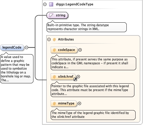
<documentation>A value used to define a graphic pattern that may be used to symbolize the lithology on a borehole log or map. The value can be optionally associated with an authority or dictionary using the codeSpace attribute and may also point to a specific graphic file using the xlink:href and mimeType attributes that contains the pattern named by the value of legendCode.</documentation>
</annotation>
</element>
<element minOccurs="0" name="matrixType" type="diggs:MatrixEnumType">
<annotation>
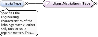
<documentation>Specifies the engineering characteristics of the lithology matrix, either soil, rock or solid organic matter. This property can typically be inferred from the classificationCode, but is included here to simplify data ingestion into data systems that may store rock and soil physical property information in different objects or tables.</documentation>
</annotation>
</element>
<element maxOccurs="unbounded" name="color" type="diggs:ColorPropertyType" minOccurs="0">
<annotation>
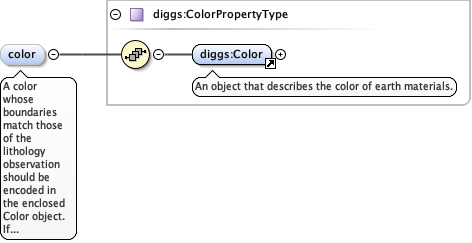
<documentation>A color whose boundaries match those of the lithology observation should be encoded in the enclosed Color object. If there are depth-specific changes in color taht are significant and do not match the boundaries of the lithologyObservation, then a ColorSystem can be defined to represent those data instead of encoding separate lithologyObservations to record only changes in color. Also, ancillary color changes in color within a lithologyObservation can be added as a description only within a PlacedObservation.</documentation>
</annotation>
</element>
<element minOccurs="0" name="constituent" type="diggs:ConstituentPropertyType" maxOccurs="unbounded">
<annotation>
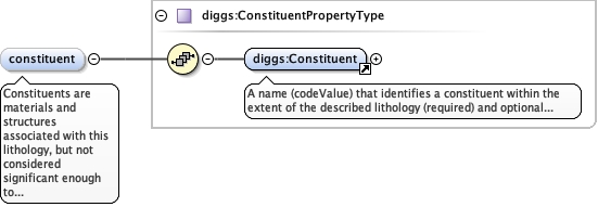
<documentation>Constituents are materials and structures associated with this lithology, but not considered significant enough to record as part of a ConstituentSystem, or where location within a lithology observation is not important to preserve (except as a comment). Constituents of a lithology are descriptions that generally fall into one of the following classes: 1) types of sedimentary or physical structures, 2) types of lithologic, mineralogic or organic accessories (eg. presence of calcite, gas odor, etc.), 3) types and degree of bioturbation features, 4) types of diagenetic structures, 5) types of physical structures produced by sampling, 6) types of fossils, 7) types of trace fossils, 8) types of fractures</documentation>
</annotation>
</element>
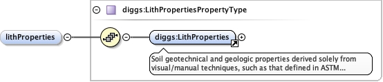
<element minOccurs="0" name="lithProperties" type="diggs:LithPropertiesPropertyType"/>
</sequence>
</extension>
</complexContent>
</complexType>
|