The 'actuate' attribute is used to communicate the desired timing of traversal from the starting resource to the ending resource; it's value should be treated as follows:onLoad - traverse to the ending resource immediately on loading the starting resource onRequest - traverse from the starting resource to the ending resource only on a post-loading event triggered for this purpose other - behavior is unconstrained; examine other markup in link for hints none - behavior is unconstrained
The 'show' attribute is used to communicate the desired presentation of the ending resource on traversal from the starting resource; it's value should be treated as follows: new - load ending resource in a new window, frame, pane, or other presentation contextreplace - load the resource in the same window, frame, pane, or other presentation contextembed - load ending resource in place of the presentation of the starting resourceother - behavior is unconstrained; examine other markup in the link for hints none - behavior is unconstrained
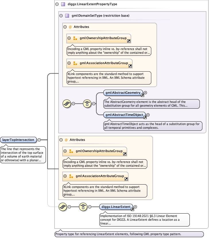
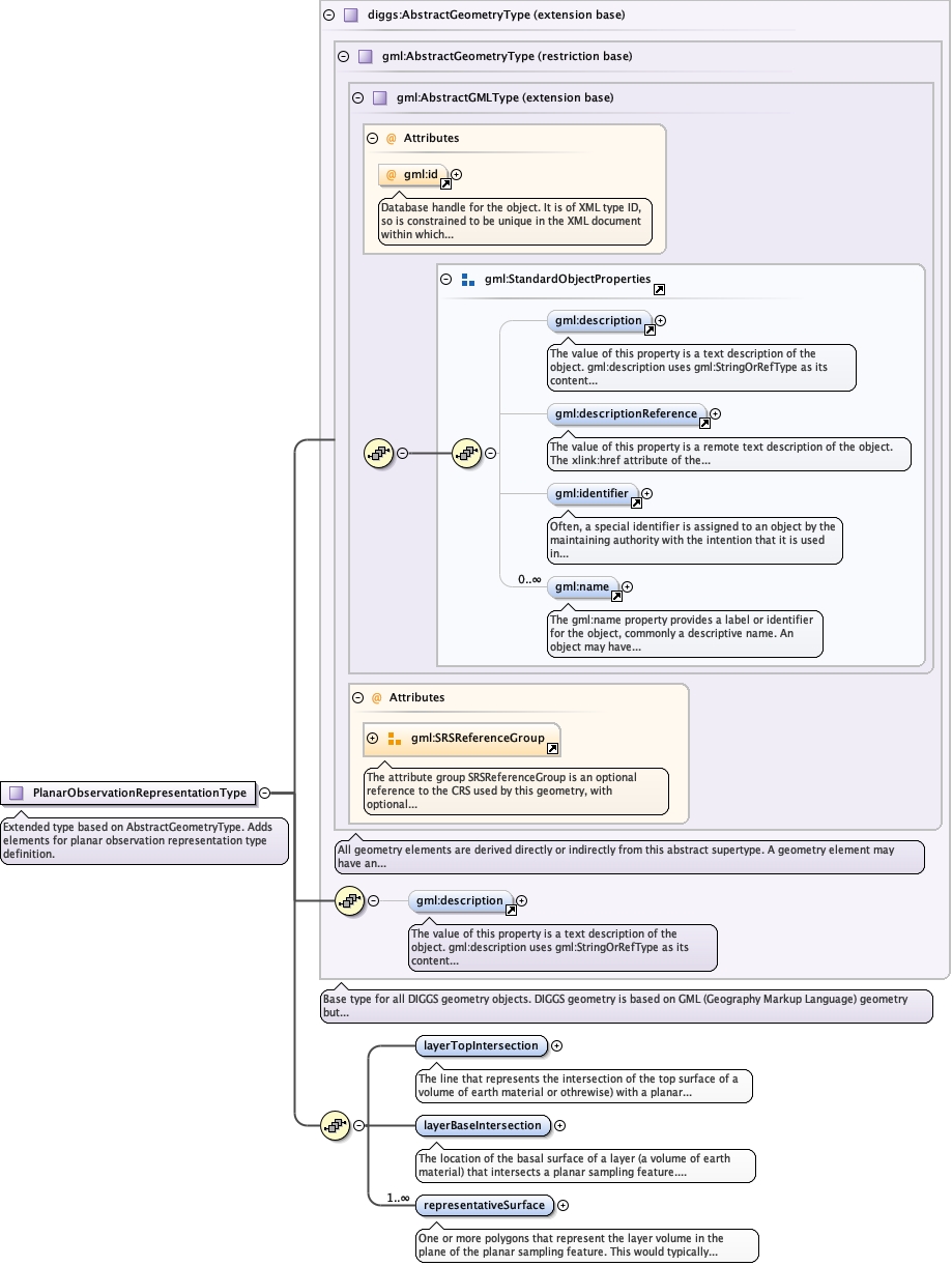
<element name="layerTopIntersection" type="diggs:LinearExtentPropertyType"><annotation><documentation>The line that represents the intersection of the top surface of a volume of earth material or othrewise) with a planar sampling feature.</documentation></annotation></element>
The location of the basal surface of a layer (a volume ofearth material) that intersects a planar sampling feature. Dependingon how a planar sampling feature is encoded, there could be multipleline strings that define this basal surface.
The 'actuate' attribute is used to communicate the desired timing of traversal from the starting resource to the ending resource; it's value should be treated as follows:onLoad - traverse to the ending resource immediately on loading the starting resource onRequest - traverse from the starting resource to the ending resource only on a post-loading event triggered for this purpose other - behavior is unconstrained; examine other markup in link for hints none - behavior is unconstrained
The 'show' attribute is used to communicate the desired presentation of the ending resource on traversal from the starting resource; it's value should be treated as follows: new - load ending resource in a new window, frame, pane, or other presentation contextreplace - load the resource in the same window, frame, pane, or other presentation contextembed - load ending resource in place of the presentation of the starting resourceother - behavior is unconstrained; examine other markup in the link for hints none - behavior is unconstrained
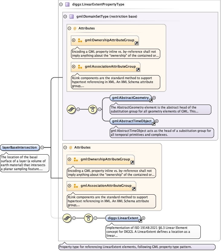
<element name="layerBaseIntersection" type="diggs:LinearExtentPropertyType"><annotation><documentation>The location of the basal surface of a layer (a volume of earth material) that intersects a planar sampling feature. Depending on how a planar sampling feature is encoded, there could be multiple line strings that define this basal surface.</documentation></annotation></element>
One or more polygons that represent the layer volume inthe plane of the planar sampling feature. This would typically be aring polygon with curve members that consist of the layer topintersection, layer bottom intersection, and two edges that wouldnormally be at the lateral extent of the planarfeature.
The 'actuate' attribute is used to communicate the desired timing of traversal from the starting resource to the ending resource; it's value should be treated as follows:onLoad - traverse to the ending resource immediately on loading the starting resource onRequest - traverse from the starting resource to the ending resource only on a post-loading event triggered for this purpose other - behavior is unconstrained; examine other markup in link for hints none - behavior is unconstrained
The 'show' attribute is used to communicate the desired presentation of the ending resource on traversal from the starting resource; it's value should be treated as follows: new - load ending resource in a new window, frame, pane, or other presentation contextreplace - load the resource in the same window, frame, pane, or other presentation contextembed - load ending resource in place of the presentation of the starting resourceother - behavior is unconstrained; examine other markup in the link for hints none - behavior is unconstrained
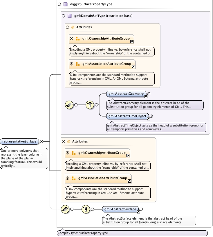
<element maxOccurs="unbounded" name="representativeSurface" type="diggs:SurfacePropertyType"><annotation><documentation>One or more polygons that represent the layer volume in the plane of the planar sampling feature. This would typically be a ring polygon with curve members that consist of the layer top intersection, layer bottom intersection, and two edges that would normally be at the lateral extent of the planar feature.</documentation></annotation></element>
Complex Type diggs:PlanarObservationRepresentationType
Namespace
http://diggsml.org/schemas/3
Annotations
Extended type based on AbstractGeometryType. Adds elements for planar observation representation type definition.
Database handle for the object. It is of XML type ID, so is constrained to beunique in the XML document within which it occurs. An external identifier for the object inthe form of a URI may be constructed using standard XML and XPointer methods. This is doneby concatenating the URI for the document, a fragment separator, and the value of the idattribute.
<complexType name="PlanarObservationRepresentationType"><annotation><documentation>Extended type based on AbstractGeometryType. Adds elements for planar observation representation type definition.</documentation></annotation><complexContent><extension base="diggs:AbstractGeometryType"><sequence><element name="layerTopIntersection" type="diggs:LinearExtentPropertyType"><annotation><documentation>The line that represents the intersection of the top surface of a volume of earth material or othrewise) with a planar sampling feature.</documentation></annotation></element><element name="layerBaseIntersection" type="diggs:LinearExtentPropertyType"><annotation><documentation>The location of the basal surface of a layer (a volume of earth material) that intersects a planar sampling feature. Depending on how a planar sampling feature is encoded, there could be multiple line strings that define this basal surface.</documentation></annotation></element><element maxOccurs="unbounded" name="representativeSurface" type="diggs:SurfacePropertyType"><annotation><documentation>One or more polygons that represent the layer volume in the plane of the planar sampling feature. This would typically be a ring polygon with curve members that consist of the layer top intersection, layer bottom intersection, and two edges that would normally be at the lateral extent of the planar feature.</documentation></annotation></element></sequence></extension></complexContent></complexType>