Showing:

Annotations
Attributes
Diagrams
Instances
Model
Properties
Source
Used by
Element diggs:ReferenceableGridByArray
Namespace http://diggsml.org/schemas/3
Annotations
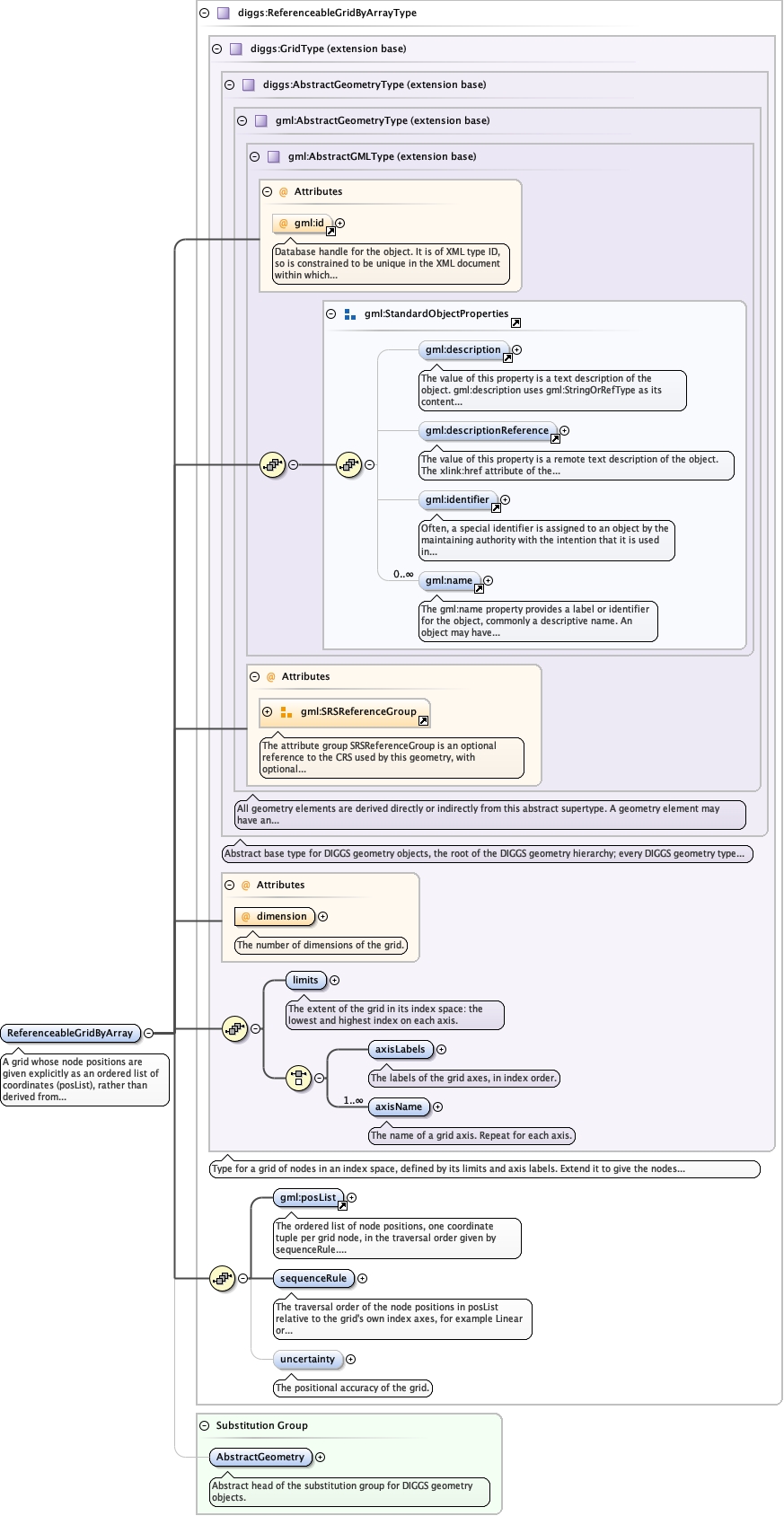
A grid whose node positions are given explicitly as an ordered list of coordinates
(posList), rather than derived from an origin and offset vectors
(diggs:RectifiedGrid). Use it for a non-uniform or terrain-draped grid, for example
a geophysical inversion mesh, where node spacing is irregular on one or more axes.
It mirrors gmlrgrid:ReferenceableGridByArrayType of GML 3.3.
Diagram
Diagramgml3_2Profile_diggs_xsd_Attribute_gml_id.tmp#idgml3_2Profile_diggs_xsd_Element_gml_description.tmp#descriptiongml3_2Profile_diggs_xsd_Element_gml_descriptionReference.tmp#descriptionReferencegml3_2Profile_diggs_xsd_Element_gml_identifier.tmp#identifiergml3_2Profile_diggs_xsd_Element_gml_name.tmp#namegml3_2Profile_diggs_xsd_Element_Group_gml_StandardObjectProperties.tmp#StandardObjectPropertiesgml3_2Profile_diggs_xsd_Complex_Type_gml_AbstractGMLType.tmp#AbstractGMLTypegml3_2Profile_diggs_xsd_Attribute_Group_gml_SRSReferenceGroup.tmp#SRSReferenceGroupgml3_2Profile_diggs_xsd_Complex_Type_gml_AbstractGeometryType.tmp#AbstractGeometryTypeCore_xsd_Complex_Type_diggs_AbstractGeometryType.tmp#http___diggsml.org_schemas_3_AbstractGeometryTypeCore_xsd_Complex_Type_diggs_GridType.tmp#GridType_dimensionCore_xsd_Complex_Type_diggs_GridType.tmp#GridType_limitsCore_xsd_Complex_Type_diggs_GridType.tmp#GridType_axisLabelsCore_xsd_Complex_Type_diggs_GridType.tmp#GridType_axisNameCore_xsd_Complex_Type_diggs_GridType.tmp#GridTypegml3_2Profile_diggs_xsd_Element_gml_posList.tmp#posListCore_xsd_Complex_Type_diggs_ReferenceableGridByArrayType.tmp#ReferenceableGridByArrayType_sequenceRuleCore_xsd_Complex_Type_diggs_ReferenceableGridByArrayType.tmp#ReferenceableGridByArrayType_uncertaintyCore_xsd_Complex_Type_diggs_ReferenceableGridByArrayType.tmp#ReferenceableGridByArrayTypeCore_xsd_Element_diggs_AbstractGeometry.tmp#http___diggsml.org_schemas_3_AbstractGeometry
Type diggs:ReferenceableGridByArrayType
Type hierarchy
Properties
content complex
Substitution Group Affiliation
Used by
Model
Children diggs:axisLabels, diggs:axisName, diggs:limits, diggs:sequenceRule, diggs:uncertainty, gml:description, gml:descriptionReference, gml:identifier, gml:name, gml:posList
Instance
<diggs:ReferenceableGridByArray axisLabels="" dimension="" gml:id="" srsDimension="" srsName="" uomLabels="" xmlns:diggs="http://diggsml.org/schemas/3" xmlns:gml="http://www.opengis.net/gml/3.2">
  <gml:description xlink:href="" nilReason="">{0,1}</gml:description>
  <gml:descriptionReference xlink:href="" nilReason="" owns="false">{0,1}</gml:descriptionReference>
  <gml:identifier codeSpace="">{0,1}</gml:identifier>
  <gml:name codeSpace="">{0,unbounded}</gml:name>
  <diggs:limits>{1,1}</diggs:limits>
  <diggs:axisLabels>{1,1}</diggs:axisLabels>
  <diggs:axisName>{1,unbounded}</diggs:axisName>
  <gml:posList axisLabels="" count="" srsDimension="" srsName="" uomLabels="">{1,1}</gml:posList>
  <diggs:sequenceRule axisOrder="">{1,1}</diggs:sequenceRule>
  <diggs:uncertainty>{0,1}</diggs:uncertainty>
</diggs:ReferenceableGridByArray>
Attributes
QName Type Use Annotation
axisLabels gml:NCNameList optional
dimension positiveInteger required
The number of dimensions of the grid.
gml:id ID optional
Database handle for the object. It is of XML type ID, so is constrained to be
unique in the XML document within which it occurs. An external identifier for the object in
the form of a URI may be constructed using standard XML and XPointer methods. This is done
by concatenating the URI for the document, a fragment separator, and the value of the id
attribute.
srsDimension positiveInteger optional
srsName anyURI optional
uomLabels gml:NCNameList optional
Source
<element name="ReferenceableGridByArray" substitutionGroup="diggs:AbstractGeometry" type="diggs:ReferenceableGridByArrayType">
  <annotation>
    <documentation>A grid whose node positions are given explicitly as an ordered list of coordinates (posList), rather than derived from an origin and offset vectors (diggs:RectifiedGrid). Use it for a non-uniform or terrain-draped grid, for example a geophysical inversion mesh, where node spacing is irregular on one or more axes. It mirrors gmlrgrid:ReferenceableGridByArrayType of GML 3.3.</documentation>
  </annotation>
</element>